Geolocate

Usingen topographic map

Click on the map to display elevation.

Usingen

The town core is about 300 m above sea level. The highest elevation in the main town of Usingen is the Hohe Berg ("High Mountain"), 414 m above sea level.

Wikipedia (CC-BY-SA 3.0)

About this map

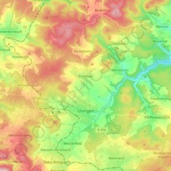
Name: Usingen topographic map, elevation, terrain.

Location: Usingen, Hochtaunuskreis, Hesse, 61250, Germany (50.30337 8.43427 50.39822 8.61206)

Average elevation: 356 m

Minimum elevation: 199 m

Maximum elevation: 545 m

Other topographic maps

Click on a map to view its topography, its elevation and its terrain.

Schmitten

Germany > Hesse > Hochtaunuskreis > Schmitten

Average elevation: 534 m

Gear up for your next adventure:

🧶550 Survival Paracord - Versatile utility cord for emergency repairs and rigging
❄️Traction Ice Cleats - Slip-on spikes for icy trails and winter hiking
🔦LED Headlamp - Hands-free lighting for early morning starts or late finishes
🥾Hiking Shorts - Breathable shorts suitable for summer hikes
🍽️Titanium Camping Spork - Ultralight and indestructible eating utensil

As an Amazon Associate, this site earns from qualifying purchases at no extra cost to you.