
Make a donation
Gear up for your next adventure:
As an Amazon Associate, this site earns from qualifying purchases at no extra cost to you.
Cerro Caracol topographic map
Click on the map to display elevation.
Make a donation
Gear up for your next adventure:
As an Amazon Associate, this site earns from qualifying purchases at no extra cost to you.
About this map
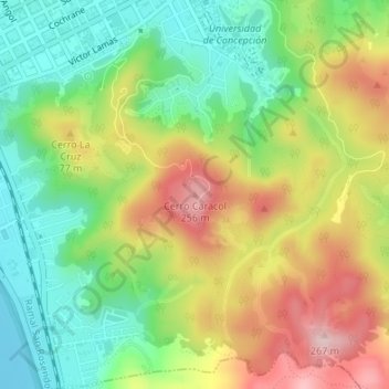
Name: Cerro Caracol topographic map, elevation, terrain.
Average elevation: 108 m
Minimum elevation: 3 m
Maximum elevation: 249 m
Make a donation
Gear up for your next adventure:
As an Amazon Associate, this site earns from qualifying purchases at no extra cost to you.
Other topographic maps
Click on a map to view its topography, its elevation and its terrain.
Laguna Lo Méndez
Chile > Región del Biobío > Provincia de Concepción > Concepción
Average elevation: 26 m
Laguna Lo Galindo
Chile > Región del Biobío > Provincia de Concepción > Concepción
Average elevation: 24 m
Laguna Las Tres Pascualas
Chile > Región del Biobío > Provincia de Concepción > Concepción
Average elevation: 23 m
Make a donation
Gear up for your next adventure:
As an Amazon Associate, this site earns from qualifying purchases at no extra cost to you.
Parque Ecuador
Chile > Región del Biobío > Provincia de Concepción > Concepción
Average elevation: 50 m
Laguna Lo Galindo
Chile > Región del Biobío > Provincia de Concepción > Concepción
Average elevation: 24 m