
Make a donation
Gear up for your next adventure:
As an Amazon Associate, this site earns from qualifying purchases at no extra cost to you.
La Forestière topographic map
Click on the map to display elevation.
Make a donation
Gear up for your next adventure:
As an Amazon Associate, this site earns from qualifying purchases at no extra cost to you.
About this map
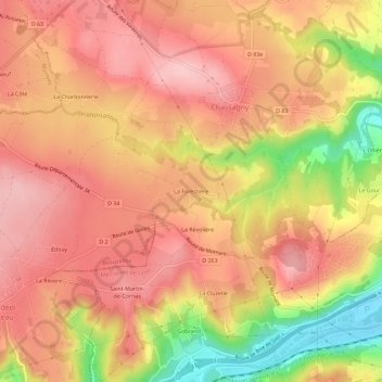
Name: La Forestière topographic map, elevation, terrain.
Average elevation: 280 m
Minimum elevation: 162 m
Maximum elevation: 340 m
Make a donation
Gear up for your next adventure:
As an Amazon Associate, this site earns from qualifying purchases at no extra cost to you.
Other topographic maps
Click on a map to view its topography, its elevation and its terrain.
Saint-Andéol-le-Château
France > Auvergne-Rhône-Alpes > Rhône > Beauvallon
Saint Andéol-le-château est situé à 328 mètres d'altitude. Les altitudes minimum et maximum sont respectivement de 189 et 363 mètres.
Average elevation: 302 m
Chassagny
France > Auvergne-Rhône-Alpes > Rhône > Beauvallon
À 300 mètres d'altitude, Chassagny se trouve sur le plateau faisant la jonction entre la vallée du Rhône à l'est, et les monts du Lyonnais à l'ouest. Son sous-sol granitique a longtemps été exploité pour en extraire de la pierre de taille.
Average elevation: 282 m