
Thank you for supporting this site ❤️
Make a donation
Make a donation
Gear up for your next adventure:
As an Amazon Associate, this site earns from qualifying purchases at no extra cost to you.
Malchingui topographic map
Click on the map to display elevation.
Thank you for supporting this site ❤️
Make a donation
Make a donation
Gear up for your next adventure:
As an Amazon Associate, this site earns from qualifying purchases at no extra cost to you.
About this map
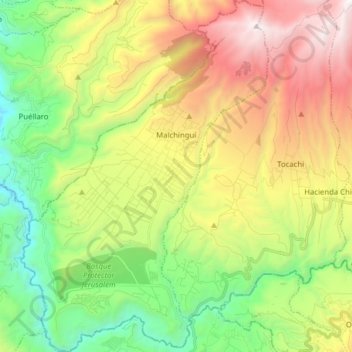
Name: Malchingui topographic map, elevation, terrain.
Location: Malchingui, Pedro Moncayo Canton, Pichincha, 171010, Ecuador (-0.03907 -78.40867 0.11716 -78.29857)
Average elevation: 2,547 m
Minimum elevation: 1,530 m
Maximum elevation: 4,020 m
Thank you for supporting this site ❤️
Make a donation
Make a donation
Gear up for your next adventure:
As an Amazon Associate, this site earns from qualifying purchases at no extra cost to you.