
Colonape topographic map
Click on the map to display elevation.
About this map
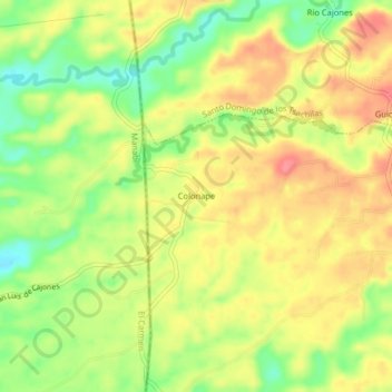
Name: Colonape topographic map, elevation, terrain.
Average elevation: 260 m
Minimum elevation: 219 m
Maximum elevation: 294 m
Other topographic maps
Click on a map to view its topography, its elevation and its terrain.
Santo Domingo de los Tsachilas
Ecuador > Santo Domingo de los Tsáchilas > Santo Domingo
Santo Domingo is located approximately 133 km west of Quito at an elevation of 625 metres or 2,051 feet. Santo Domingo lies in the foothills west of the Andes. It is important stopping point on the road from Quito to the Pacific coast. The city also connects other lowland cities like Quevedo, Chone, and…
Average elevation: 695 m