
Make a donation
Gear up for your next adventure:
As an Amazon Associate, this site earns from qualifying purchases at no extra cost to you.
Pichl an der Raab topographic map
Click on the map to display elevation.
Make a donation
Gear up for your next adventure:
As an Amazon Associate, this site earns from qualifying purchases at no extra cost to you.
About this map
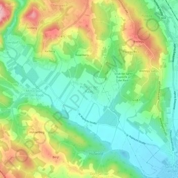
Name: Pichl an der Raab topographic map, elevation, terrain.
Average elevation: 443 m
Minimum elevation: 376 m
Maximum elevation: 555 m
Make a donation
Gear up for your next adventure:
As an Amazon Associate, this site earns from qualifying purchases at no extra cost to you.
Other topographic maps
Click on a map to view its topography, its elevation and its terrain.
Fischbach
Austria > Styria > Bezirk Weiz
Fischbach is a town in the Fischbacher Alpen and is located about 12 km (7.5 mi) northwest of Birkfeld and about 27 km (17 mi) air-line distance from the district capital Weiz. The maximum north-south extension as well as the maximum east-west extension are each about nine kilometers (5.6 mi). The municipality…
Average elevation: 1,024 m
Make a donation
Gear up for your next adventure:
As an Amazon Associate, this site earns from qualifying purchases at no extra cost to you.