Geolocate

Chandur topographic map

Click on the map to display elevation.

Chandur

Chandur is located at 16°59′N 79°04′E / 16.98°N 79.06°E / 16.98; 79.06. It has an average elevation of 484 metres (1587 feet).

Wikipedia (CC-BY-SA 3.0)

About this map

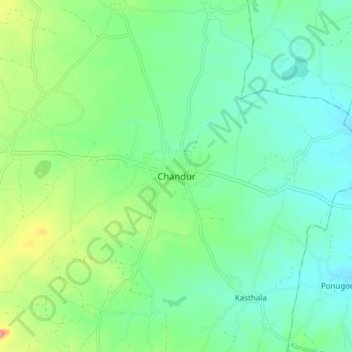
Name: Chandur topographic map, elevation, terrain.

Location: Chandur, Chandur mandal, Nalgonda, Telangana, 508255, India (16.93944 79.01841 17.01944 79.09841)

Average elevation: 256 m

Minimum elevation: 231 m

Maximum elevation: 317 m

Gear up for your next adventure:

🩹Moleskin Blister Pads - Direct protection for painful foot pressure points
🥾Light Trekking Boots - Supportive boots for multi-day treks
🧥Softshell Jacket - Windproof and breathable jacket for hiking
🔋Lithium AA Batteries - Long-lasting power that performs in extreme cold
🧢Beanie Hat - Keep your head warm in cold weather

As an Amazon Associate, this site earns from qualifying purchases at no extra cost to you.