
Make a donation
Gear up for your next adventure:
As an Amazon Associate, this site earns from qualifying purchases at no extra cost to you.
Hashtgerd topographic map
Click on the map to display elevation.
Make a donation
Gear up for your next adventure:
As an Amazon Associate, this site earns from qualifying purchases at no extra cost to you.
About this map
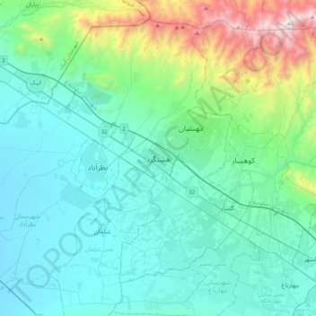
Name: Hashtgerd topographic map, elevation, terrain.
Average elevation: 1,516 m
Minimum elevation: 1,148 m
Maximum elevation: 3,270 m
Make a donation
Gear up for your next adventure:
As an Amazon Associate, this site earns from qualifying purchases at no extra cost to you.
Other topographic maps
Click on a map to view its topography, its elevation and its terrain.
Mehestan
Iran > Alborz Province > Savojbolagh County
Mehestan is in the west of Alborz province at an altitude of 1,310 to 1,610 meters above sea level and between longitudes of 50 degrees 25 minutes and 50 degrees 55 minutes and latitudes of 35 degrees 45 minutes and 36 degrees 5 minutes. Hashtgerd plain generally has cold winters and hot and dry summers, but…
Average elevation: 1,425 m
Mehestan
Iran > Alborz Province > Savojbolagh County
The new city of Mehestan is geographically located in the west of Alborz province at an altitude of 1,310 to 1,610 meters above sea level and between longitudes of 50 degrees 25 minutes and 50 degrees 55 minutes and latitudes of 35 degrees 45 minutes and 36 degrees 5 minutes. Hashtgerd plain generally has cold…
Average elevation: 1,425 m