Geolocate

Baua topographic map

Click on the map to display elevation.

About this map

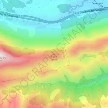
Name: Baua topographic map, elevation, terrain.

Location: Baua, Ribeseya, Asturias, 33568, Spain (43.42678 -4.99688 43.42688 -4.99678)

Average elevation: 322 m

Minimum elevation: 46 m

Maximum elevation: 727 m

Gear up for your next adventure:

🩹Moleskin Blister Pads - Direct protection for painful foot pressure points
🧥Insulated Jacket - Keep warm in cold outdoor conditions
🧦Crew Hiking Socks - Comfortable socks for long-distance hikes
🧭GPS Tracker - Track your location in remote areas safely
🧥Thermal Fleece Jacket - Versatile insulation for changing mountain temperatures

As an Amazon Associate, this site earns from qualifying purchases at no extra cost to you.