
Challans topographic map
Click on the map to display elevation.
About this map
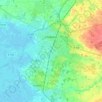
Name: Challans topographic map, elevation, terrain.
Average elevation: 16 m
Minimum elevation: -2 m
Maximum elevation: 59 m
Other topographic maps
Click on a map to view its topography, its elevation and its terrain.
La Grande Richardière
France > Pays de la Loire > Vendée > Aubigny-Les Clouzeaux > Les Clouzeaux
Average elevation: 54 m
La Chervinière
France > Pays de la Loire > Vendée > Rives-du-Fougerais > Saint-Sulpice-en-Pareds
Average elevation: 87 m
La Boutinardière
France > Pays de la Loire > Vendée > Chanverrie > Chambretaud
Average elevation: 200 m
Mareuil-sur-Lay-Dissais
France > Pays de la Loire > Vendée > Mareuil-sur-Lay-Dissais > Mareuil-sur-Lay-Dissais
Average elevation: 27 m