
Thank you for supporting this site ❤️
Make a donation
Make a donation
Gear up for your next adventure:
As an Amazon Associate, this site earns from qualifying purchases at no extra cost to you.
High Uintas Wilderness topographic map
Click on the map to display elevation.
Thank you for supporting this site ❤️
Make a donation
Make a donation
Gear up for your next adventure:
As an Amazon Associate, this site earns from qualifying purchases at no extra cost to you.
About this map
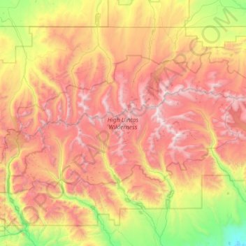
Name: High Uintas Wilderness topographic map, elevation, terrain.
Average elevation: 2,919 m
Minimum elevation: 1,797 m
Maximum elevation: 4,104 m
Thank you for supporting this site ❤️
Make a donation
Make a donation
Gear up for your next adventure:
As an Amazon Associate, this site earns from qualifying purchases at no extra cost to you.
Other topographic maps
Click on a map to view its topography, its elevation and its terrain.
Kings Peak
United States > Utah > Duchesne County
Kings Peak is the highest peak in the U.S. state of Utah, with an elevation of 13,528 feet (4,123 m) NAVD 88.
Average elevation: 3,743 m