
Baker topographic map
Click on the map to display elevation.
About this map
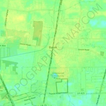
Name: Baker topographic map, elevation, terrain.
Average elevation: 24 m
Minimum elevation: 15 m
Maximum elevation: 31 m
Other topographic maps
Click on a map to view its topography, its elevation and its terrain.
Nicholson Estates
United States > Louisiana > East Baton Rouge Parish > Baton Rouge
Average elevation: 11 m
Delmont Place
United States > Louisiana > East Baton Rouge Parish > Baton Rouge
Average elevation: 20 m
Goodwood Estates
United States > Louisiana > East Baton Rouge Parish > Baton Rouge
Average elevation: 17 m
Sherwood Forest
United States > Louisiana > East Baton Rouge Parish > Baton Rouge
Average elevation: 16 m
Magnolia Heights
United States > Louisiana > East Baton Rouge Parish > Baton Rouge
Average elevation: 11 m
Carmen Terrace
United States > Louisiana > East Baton Rouge Parish > Baton Rouge
Average elevation: 16 m
Bell Fontaine
United States > Louisiana > East Baton Rouge Parish > Baton Rouge
Average elevation: 16 m
Marwede Place
United States > Louisiana > East Baton Rouge Parish > Baton Rouge
Average elevation: 17 m
Monte Sano Trailer Park
United States > Louisiana > East Baton Rouge Parish > Baton Rouge > Monte Sano Trailer Park
Average elevation: 21 m
Sharon Hills
United States > Louisiana > East Baton Rouge Parish > Sharon Hills
Average elevation: 20 m