
Thank you for supporting this site ❤️
Make a donation
Make a donation
Gear up for your next adventure:
As an Amazon Associate, this site earns from qualifying purchases at no extra cost to you.
Städlen topographic map
Click on the map to display elevation.
Thank you for supporting this site ❤️
Make a donation
Make a donation
Gear up for your next adventure:
As an Amazon Associate, this site earns from qualifying purchases at no extra cost to you.
About this map
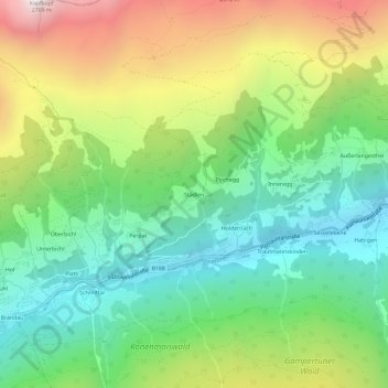
Name: Städlen topographic map, elevation, terrain.
Location: Städlen, Kappl, Bezirk Landeck, Tirol, 6555, Österreich (47.05777 10.39601 47.09777 10.43601)
Average elevation: 1,663 m
Minimum elevation: 1,075 m
Maximum elevation: 2,680 m
Thank you for supporting this site ❤️
Make a donation
Make a donation
Gear up for your next adventure:
As an Amazon Associate, this site earns from qualifying purchases at no extra cost to you.