Geolocate

Sardis topographic map

Click on the map to display elevation.

About this map

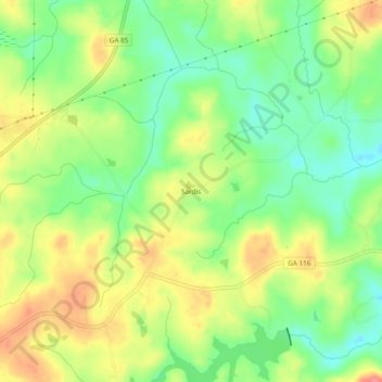
Name: Sardis topographic map, elevation, terrain.

Location: Sardis, Talbot County, Georgia, United States (32.77652 -84.65881 32.81652 -84.61881)

Average elevation: 235 m

Minimum elevation: 200 m

Maximum elevation: 275 m

Other topographic maps

Click on a map to view its topography, its elevation and its terrain.

Talbotton

United States > Georgia > Talbot County

Average elevation: 203 m

Gear up for your next adventure:

🥾All-Terrain Hiking Boots - Versatile boots for varied hiking conditions
🥾Lightweight Hiking Shoes - Comfortable shoes for day hikes
💡LED Camping Lantern - Illuminate your campsite with long-lasting lanterns
🥾Mountain Hiking Boots - High-traction boots for rocky terrain
🧥Softshell Hiking Jacket - The perfect balance of wind protection and breathability

As an Amazon Associate, this site earns from qualifying purchases at no extra cost to you.