Geolocate

Fiandrini topographic map

Click on the map to display elevation.

About this map

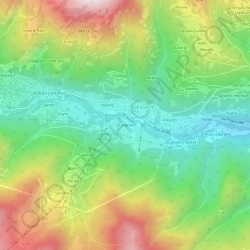
Name: Fiandrini topographic map, elevation, terrain.

Location: Fiandrini, Sampeyre, Cuneo, Piemonte, Italia (44.55674 7.16495 44.59674 7.20495)

Average elevation: 1,281 m

Minimum elevation: 877 m

Maximum elevation: 1,910 m

Other topographic maps

Click on a map to view its topography, its elevation and its terrain.

Lago di Luca

Italia > Piemonte > Cuneo > Sampeyre

Average elevation: 2,342 m

Gear up for your next adventure:

🧢Outdoor Visor - Breathable visor for sunny hikes
🧥Softshell Hiking Jacket - The perfect balance of wind protection and breathability
🧥Packable Rain Jacket - Breathable waterproof layer for unpredictable weather
🚲Heavy Duty Bike Lock - Secure your bike at the trailhead or during stops
🧊Insulated Water Bottle - Keeps drinks cold in summer and prevents freezing in winter

As an Amazon Associate, this site earns from qualifying purchases at no extra cost to you.