
Make a donation
Gear up for your next adventure:
As an Amazon Associate, this site earns from qualifying purchases at no extra cost to you.
La Isla topographic map
Click on the map to display elevation.
Make a donation
Gear up for your next adventure:
As an Amazon Associate, this site earns from qualifying purchases at no extra cost to you.
About this map
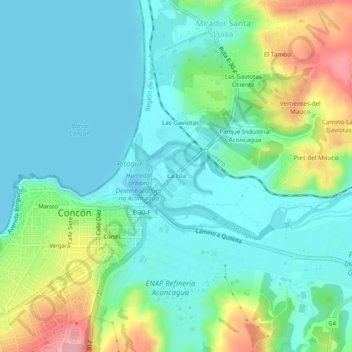
Name: La Isla topographic map, elevation, terrain.
Average elevation: 35 m
Minimum elevation: -3 m
Maximum elevation: 133 m
Make a donation
Gear up for your next adventure:
As an Amazon Associate, this site earns from qualifying purchases at no extra cost to you.
Other topographic maps
Click on a map to view its topography, its elevation and its terrain.
Dunas de Concón
Chile > Región de Valparaíso > Provincia de Valparaíso > Concón
Average elevation: 48 m
Humedal Urbano Desembocadura río Aconcagua
Chile > Región de Valparaíso > Provincia de Valparaíso > Concón > Mirador Santa Luisa > Las Gaviotas
Average elevation: 23 m
Playa Amarilla
Chile > Región de Valparaíso > Provincia de Valparaíso > Concón
Average elevation: 29 m
La Boca
Chile > Región de Valparaíso > Provincia de Valparaíso > Concón > La Isla
Average elevation: 22 m
Make a donation
Gear up for your next adventure:
As an Amazon Associate, this site earns from qualifying purchases at no extra cost to you.
Dunas de Concón
Chile > Región de Valparaíso > Provincia de Valparaíso > Concón
Average elevation: 48 m
Playa Las Conchitas
Chile > Región de Valparaíso > Provincia de Valparaíso > Concón
Average elevation: 51 m
La Boca
Chile > Región de Valparaíso > Provincia de Valparaíso > Concón > La Isla
Average elevation: 22 m