
Make a donation
Gear up for your next adventure:
As an Amazon Associate, this site earns from qualifying purchases at no extra cost to you.
Hitzacker (Elbe) topographic map
Click on the map to display elevation.
Make a donation
Gear up for your next adventure:
As an Amazon Associate, this site earns from qualifying purchases at no extra cost to you.
Hitzacker (Elbe)
Hitzacker liegt an der Einmündung der Jeetzel in die Elbe. Während die Elbhöhen (auch: Klötzie), an deren südöstlichem Fuß sich Hitzacker befindet, naturräumlich bereits zur Lüneburger Heide gehören (vergleiche hierzu: Drawehn), zählen die Niederungsgebiete der Altstadt zur Elbtalaue.
Make a donation
Gear up for your next adventure:
As an Amazon Associate, this site earns from qualifying purchases at no extra cost to you.
About this map
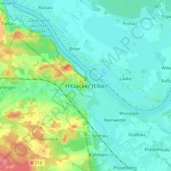
Name: Hitzacker (Elbe) topographic map, elevation, terrain.
Average elevation: 25 m
Minimum elevation: 7 m
Maximum elevation: 92 m
Make a donation
Gear up for your next adventure:
As an Amazon Associate, this site earns from qualifying purchases at no extra cost to you.