Geolocate

Surla topographic map

Click on the map to display elevation.

About this map

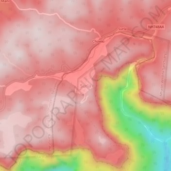
Name: Surla topographic map, elevation, terrain.

Location: Surla, Satari, North Goa, Goa, India (15.64965 74.15303 15.68965 74.19303)

Average elevation: 711 m

Minimum elevation: 281 m

Maximum elevation: 846 m

Other topographic maps

Click on a map to view its topography, its elevation and its terrain.

Mhadei Wildlife Sanctuary

India > Goa > Satari

Average elevation: 364 m

Surla

India > Goa > Satari > Nanorem

Average elevation: 384 m

Mhadei Wildlife Sanctuary

India > Goa > Satari > Caranzol

Average elevation: 415 m

Gear up for your next adventure:

🔋Lithium AA Batteries - Long-lasting power that performs in extreme cold
🦯Trekking Poles - Reduced impact on joints for steep topographic climbs
🧥Fleece Jacket - Warm and lightweight jacket for layering
🪑Insulated Seat Pad - Protect your seat from cold rocks and wet logs
🧥Packable Rain Jacket - Breathable waterproof layer for unpredictable weather

As an Amazon Associate, this site earns from qualifying purchases at no extra cost to you.