
Make a donation
Gear up for your next adventure:
As an Amazon Associate, this site earns from qualifying purchases at no extra cost to you.
Freiburg im Breisgau topographic map
Click on the map to display elevation.
Make a donation
Gear up for your next adventure:
As an Amazon Associate, this site earns from qualifying purchases at no extra cost to you.
About this map
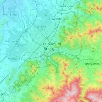
Name: Freiburg im Breisgau topographic map, elevation, terrain.
Location: Freiburg im Breisgau, Baden-Württemberg, Germany (47.90358 7.66201 48.07106 7.93084)
Average elevation: 407 m
Minimum elevation: 187 m
Maximum elevation: 1,277 m
Make a donation
Gear up for your next adventure:
As an Amazon Associate, this site earns from qualifying purchases at no extra cost to you.
Other topographic maps
Click on a map to view its topography, its elevation and its terrain.
Nabern
Germany > Baden-Württemberg > Landkreis Esslingen > Kirchheim unter Teck
Average elevation: 385 m
Make a donation
Gear up for your next adventure:
As an Amazon Associate, this site earns from qualifying purchases at no extra cost to you.