Geolocate

Frontino topographic map

Click on the map to display elevation.

About this map

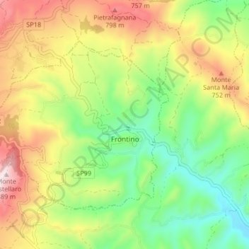
Name: Frontino topographic map, elevation, terrain.

Location: Frontino, Pesaro e Urbino, Marche, Italy (43.75110 12.32223 43.78356 12.38843)

Average elevation: 562 m

Minimum elevation: 325 m

Maximum elevation: 884 m

Gear up for your next adventure:

🧴Outdoor Sunscreen - High SPF protection for high-altitude UV exposure
❄️Traction Ice Cleats - Slip-on spikes for icy trails and winter hiking
🥾Approach Boots - Comfortable boots for hiking and climbing approaches
Lightweight Camping Tent - Portable shelter optimized for Canadian backcountry camping
🧤Rechargeable Heated Gloves - Extreme warmth for Canadian winter expeditions

As an Amazon Associate, this site earns from qualifying purchases at no extra cost to you.