Geolocate

Bremerhaven topographic map

Click on the map to display elevation.

About this map

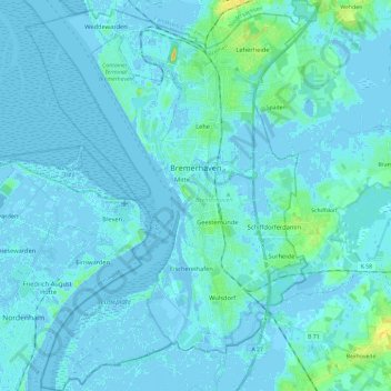
Name: Bremerhaven topographic map, elevation, terrain.

Location: Bremerhaven, Bremen, Germany (53.47117 8.48301 53.61019 8.65918)

Average elevation: 2 m

Minimum elevation: -7 m

Maximum elevation: 20 m

Gear up for your next adventure:

🧢Hiking Hat - Sun-protective and breathable hats for long treks
🧊Insulated Water Bottle - Keeps drinks cold in summer and prevents freezing in winter
🥾Trail Hiking Boots - Supportive boots for rough trails
🥾Trail Hiking Shoes - Durable shoes designed for rugged trails
🪑Insulated Seat Pad - Protect your seat from cold rocks and wet logs

As an Amazon Associate, this site earns from qualifying purchases at no extra cost to you.