Geolocate

Dettelbach topographic map

Click on the map to display elevation.

About this map

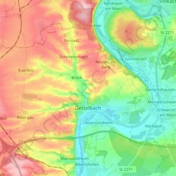
Name: Dettelbach topographic map, elevation, terrain.

Location: Dettelbach, Landkreis Kitzingen, Bavaria, 97337, Germany (49.77690 10.05625 49.84952 10.20930)

Average elevation: 242 m

Minimum elevation: 183 m

Maximum elevation: 318 m

Other topographic maps

Click on a map to view its topography, its elevation and its terrain.

Langenberg

Germany > Bavaria > Landkreis Kitzingen

Average elevation: 399 m

Enheim

Germany > Bavaria > Landkreis Kitzingen

Average elevation: 290 m

Köhler

Germany > Bavaria > Landkreis Kitzingen > Volkach

Average elevation: 252 m

Euerfeld

Germany > Bavaria > Landkreis Kitzingen > Dettelbach

Average elevation: 276 m

Gear up for your next adventure:

🧤Thermal Hiking Gloves - Grip-enhanced gloves for cold-weather altitude trekking
🥾Hiking Shoes - Durable and comfortable shoes for trail hiking
🧢Sun Hat - Wide-brim hat for sun protection
🧭GPS Tracker - Track your location in remote areas safely
🧳Compression Sacks - Maximize space in your backpack by shrinking gear

As an Amazon Associate, this site earns from qualifying purchases at no extra cost to you.