Geolocate

Tafalla topographic map

Click on the map to display elevation.

About this map

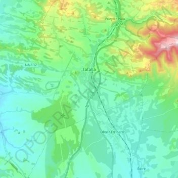
Name: Tafalla topographic map, elevation, terrain.

Location: Tafalla, Erdialdea / Zona Media, Navarre, Spain (42.44692 -1.79439 42.57916 -1.61527)

Average elevation: 453 m

Minimum elevation: 337 m

Maximum elevation: 872 m

Gear up for your next adventure:

👟Trail Running Shoes - Agile footwear for fast-paced topographic exploration
🧥Softshell Hiking Jacket - The perfect balance of wind protection and breathability
🛏️Camping Sleeping Mat - Comfortable mats for sleeping outdoors
🥽Outdoor Goggles - Protective eyewear for outdoor activities
🧰Multitool Knife - Compact and versatile tool for outdoor use

As an Amazon Associate, this site earns from qualifying purchases at no extra cost to you.