Geolocate

Mogadore topographic map

Click on the map to display elevation.

About this map

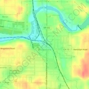
Name: Mogadore topographic map, elevation, terrain.

Location: Mogadore, Summit County, Ohio, United States (41.03900 -81.41701 41.06544 -81.38296)

Average elevation: 346 m

Minimum elevation: 319 m

Maximum elevation: 373 m

Other topographic maps

Click on a map to view its topography, its elevation and its terrain.

Sagamore Hills

United States > Ohio > Summit County

Average elevation: 264 m

Camp Crowell Dam

United States > Ohio > Summit County

Average elevation: 355 m

Brandywine Falls

United States > Ohio > Summit County

Average elevation: 265 m

Silver Springs Lake

United States > Ohio > Summit County > Stow

Average elevation: 333 m

Greensburg

United States > Ohio > Summit County > Green

Average elevation: 358 m

West Richfield

United States > Ohio > Summit County > Richfield

Average elevation: 359 m

Six Corners

United States > Ohio > Summit County > Tallmadge

Average elevation: 350 m

East Center

United States > Ohio > Summit County > Richfield > East Center

Average elevation: 343 m

Gear up for your next adventure:

🧥Waterproof Hiking Jacket - Protect yourself from rain and wind while hiking
Camping Groundsheet - Protect your tent from moisture and dirt
🧭GPS Handheld Device - Reliable GPS navigation for outdoor adventures
🧢Sun Hat - Wide-brim hat for sun protection
🧭GPS Outdoor Watch - Smart watch for navigation and fitness tracking in nature

As an Amazon Associate, this site earns from qualifying purchases at no extra cost to you.