
Mattsee topographic map
Interactive map
Click on the map to display elevation.
About this map
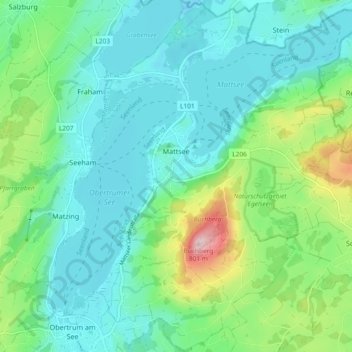
Name: Mattsee topographic map, elevation, terrain.
Location: Mattsee, Bezirk Salzburg-Umgebung, Salzbourg, 5163, Autriche (47.93441 13.06952 47.99675 13.15124)
Average elevation: 562 m
Minimum elevation: 494 m
Maximum elevation: 788 m
Other topographic maps
Click on a map to view its topography, its elevation and its terrain.
Waldprechting
Autriche > Salzbourg > Bezirk Salzburg-Umgebung > Seekirchen am Wallersee
Waldprechting, Seekirchen am Wallersee, Bezirk Salzburg-Umgebung, Salzbourg, 5201, Autriche
Average elevation: 552 m
Anif
Autriche > Salzbourg > Bezirk Salzburg-Umgebung
Anif, Bezirk Salzburg-Umgebung, Salzbourg, 5081, Autriche
Average elevation: 443 m
Eisenmühle
Autriche > Salzbourg > Bezirk Salzburg-Umgebung > Fraham
Eisenmühle, Fraham, Seeham, Bezirk Salzburg-Umgebung, Salzbourg, 5164, Autriche
Average elevation: 547 m
Stockham
Autriche > Salzbourg > Bezirk Salzburg-Umgebung > Stockham
Stockham, Straßwalchen, Bezirk Salzburg-Umgebung, Salzbourg, 5204, Autriche
Average elevation: 608 m
Fuschlsee
Autriche > Salzbourg > Bezirk Salzburg-Umgebung > Brunn
Fuschlsee, Brunn, Fuschl am See, Bezirk Salzburg-Umgebung, Salzbourg, 5330, Autriche
Average elevation: 771 m