Geolocate

Santolan topographic map

Click on the map to display elevation.

About this map

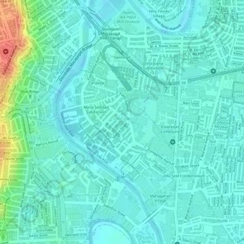
Name: Santolan topographic map, elevation, terrain.

Location: Santolan, Pasig, Metro Manila, 1610, Philippines (14.60541 121.07840 14.62334 121.09270)

Average elevation: 16 m

Minimum elevation: 2 m

Maximum elevation: 62 m

Other topographic maps

Click on a map to view its topography, its elevation and its terrain.

Pasig River

Philippines > Pasig

Average elevation: 14 m

Ortigas Park

Philippines > Pasig

Average elevation: 36 m

Pasig City Cemetery

Philippines > Pasig

Average elevation: 9 m

Parian Creek

Philippines > Pasig

Average elevation: 6 m

Bridgetowne Central Park

Philippines > Pasig

Average elevation: 11 m

Parian Creek

Philippines > Pasig

Average elevation: 6 m

Gear up for your next adventure:

🥘Camping Cookware Set - Compact nesting pots and pans for trail cooking
📷Outdoor Action Camera - Capture high-elevation views and rugged adventures
👖Convertible Hiking Pants - Zip-off legs to adapt to changing weather conditions
💧Collapsible Water Bottle - Space-saving water bottle for outdoor activities
🥾Trekking Boots - Durable boots for long-distance trekking

As an Amazon Associate, this site earns from qualifying purchases at no extra cost to you.