
Thank you for supporting this site ❤️
Make a donation
Make a donation
Gear up for your next adventure:
As an Amazon Associate, this site earns from qualifying purchases at no extra cost to you.
Muliyar topographic map
Click on the map to display elevation.
Thank you for supporting this site ❤️
Make a donation
Make a donation
Gear up for your next adventure:
As an Amazon Associate, this site earns from qualifying purchases at no extra cost to you.
About this map
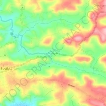
Name: Muliyar topographic map, elevation, terrain.
Location: Muliyar, Kasaragod, Kasaragod District, Kerala, 671542, India (12.49363 75.09325 12.53363 75.13325)
Average elevation: 93 m
Minimum elevation: 13 m
Maximum elevation: 176 m
Thank you for supporting this site ❤️
Make a donation
Make a donation
Gear up for your next adventure:
As an Amazon Associate, this site earns from qualifying purchases at no extra cost to you.