
Make a donation
Gear up for your next adventure:
As an Amazon Associate, this site earns from qualifying purchases at no extra cost to you.
In der Helle topographic map
Click on the map to display elevation.
Make a donation
Gear up for your next adventure:
As an Amazon Associate, this site earns from qualifying purchases at no extra cost to you.
About this map
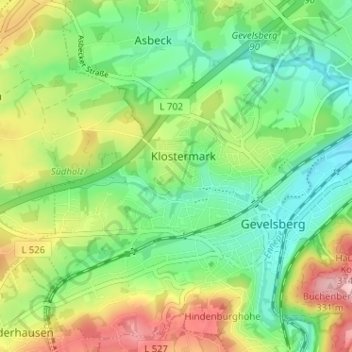
Name: In der Helle topographic map, elevation, terrain.
Average elevation: 218 m
Minimum elevation: 149 m
Maximum elevation: 336 m
Make a donation
Gear up for your next adventure:
As an Amazon Associate, this site earns from qualifying purchases at no extra cost to you.
Other topographic maps
Click on a map to view its topography, its elevation and its terrain.
Silschede
Deutschland > Nordrhein-Westfalen > Ennepe-Ruhr-Kreis > Gevelsberg
Silschede liegt im Norden des Stadtgebiets von Gevelsberg im Niederbergisch-Märkischen Hügelland. Der Ortskern von Silschede, das aufgrund seiner Lage auch als „Höhendorf“ bezeichnet wird, liegt ca. zwei Kilometer nördlich der Gevelsberger Kernstadt. Weitere kleinere Ansiedlungen auf dem Gebiet der…
Average elevation: 215 m