
Gharzouz topographic map
Interactive map
Click on the map to display elevation.
About this map
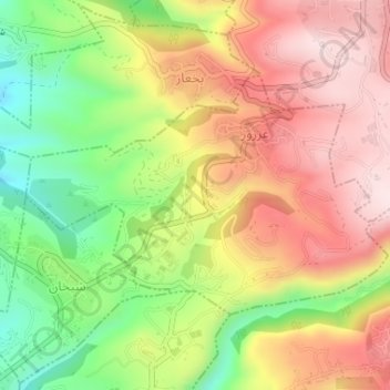
Name: Gharzouz topographic map, elevation, terrain.
Average elevation: 357 m
Minimum elevation: 153 m
Maximum elevation: 537 m
Other topographic maps
Click on a map to view its topography, its elevation and its terrain.
Aramoun
Liban > Gouvernorat de Kesrouan-Jbeil
Aramoun, District de Kesrouan, Gouvernorat de Kesrouan-Jbeil, Liban
Average elevation: 823 m
Jeita
Liban > Gouvernorat de Kesrouan-Jbeil
Jeita, District de Kesrouan, Gouvernorat de Kesrouan-Jbeil, Liban
Average elevation: 316 m
District de Jbeil
Liban > Gouvernorat de Kesrouan-Jbeil
District de Jbeil, Gouvernorat de Kesrouan-Jbeil, Liban
Average elevation: 1,160 m
Jbeil
Liban > Gouvernorat de Kesrouan-Jbeil
Jbeil, District de Jbeil, Gouvernorat de Kesrouan-Jbeil, 4504, Liban
Average elevation: 64 m