
Make a donation
Gear up for your next adventure:
As an Amazon Associate, this site earns from qualifying purchases at no extra cost to you.
Eastern Region topographic map
Click on the map to display elevation.
Make a donation
Gear up for your next adventure:
As an Amazon Associate, this site earns from qualifying purchases at no extra cost to you.
About this map
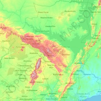
Name: Eastern Region topographic map, elevation, terrain.
Location: Eastern Region, Ghana (5.70084 -1.24707 7.21284 0.21658)
Average elevation: 165 m
Minimum elevation: -1 m
Maximum elevation: 827 m
Make a donation
Gear up for your next adventure:
As an Amazon Associate, this site earns from qualifying purchases at no extra cost to you.
Other topographic maps
Click on a map to view its topography, its elevation and its terrain.
Sunyani
Ghana > Bono Region > Sunyani Municipal District
Sunyani is located at 07°20′N 02°20′W / 7.333°N 2.333°W / 7.333; -2.333 (7.333333, -2.333333), approximately 105 miles (169 km) southwest of Kumasi and 300 miles (480 km) away from Accra. The city have an average elevation of 308 metres (1,010 ft).
Average elevation: 276 m
Make a donation
Gear up for your next adventure:
As an Amazon Associate, this site earns from qualifying purchases at no extra cost to you.
Make a donation
Gear up for your next adventure:
As an Amazon Associate, this site earns from qualifying purchases at no extra cost to you.