
Mehlmeisel topographic map
Interactive map
Click on the map to display elevation.
About this map
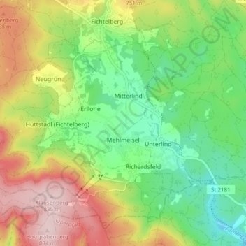
Name: Mehlmeisel topographic map, elevation, terrain.
Location: Mehlmeisel, Landkreis Bayreuth, Bayern, 95694, Deutschland (49.96042 11.82842 49.99879 11.90450)
Average elevation: 670 m
Minimum elevation: 556 m
Maximum elevation: 834 m
Other topographic maps
Click on a map to view its topography, its elevation and its terrain.
Warmensteinach
Deutschland > Bayern > Landkreis Bayreuth
Warmensteinach, Landkreis Bayreuth, Bayern, 95485, Deutschland
Average elevation: 738 m
Speichersdorf
Deutschland > Bayern > Landkreis Bayreuth
Speichersdorf, Landkreis Bayreuth, Bayern, 95469, Deutschland
Average elevation: 482 m
Glashütten
Deutschland > Bayern > Landkreis Bayreuth
Glashütten, Mistelgau (VGem), Landkreis Bayreuth, Bayern, 95496, Deutschland
Average elevation: 468 m
Veldensteiner Forst
Deutschland > Bayern > Landkreis Bayreuth
Veldensteiner Forst, Landkreis Bayreuth, Bayern, Deutschland
Average elevation: 450 m
Pottenstein
Deutschland > Bayern > Landkreis Bayreuth
Pottenstein, Landkreis Bayreuth, Bayern, 91278, Deutschland
Average elevation: 471 m
Bad Berneck im Fichtelgebirge
Deutschland > Bayern > Landkreis Bayreuth
Bad Berneck im Fichtelgebirge, Landkreis Bayreuth, Bayern, 95460, Deutschland
Average elevation: 521 m
Goldkronach
Deutschland > Bayern > Landkreis Bayreuth
Goldkronach, Landkreis Bayreuth, Bayern, 95497, Deutschland
Average elevation: 527 m
Aufseß
Deutschland > Bayern > Landkreis Bayreuth > Aufseß
Aufseß, Hollfeld (VGem), Landkreis Bayreuth, Bayern, 91347, Deutschland
Average elevation: 445 m