Geolocate

Mansourah topographic map

Click on the map to display elevation.

About this map

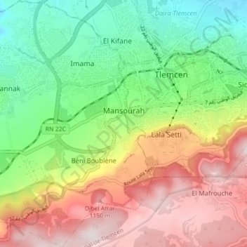
Name: Mansourah topographic map, elevation, terrain.

Location: Mansourah, Mansourah District, Tlemcen, Algeria (34.84126 -1.38636 34.89920 -1.32227)

Average elevation: 902 m

Minimum elevation: 644 m

Maximum elevation: 1,231 m

Gear up for your next adventure:

🐕Hiking Dog Pack - Let your canine companion carry their own water and food
🛶Kayak Accessories - Essential gear for safe and fun kayaking adventures
🛏️Sleeping Bag - Warm and compact sleeping bags for outdoor camping
🗺️Topographic Maps - Detailed maps to explore trails, mountains, and wilderness areas
🧭GPS Tracker - Track your location in remote areas safely

As an Amazon Associate, this site earns from qualifying purchases at no extra cost to you.