Geolocate

Tiguib topographic map

Click on the map to display elevation.

About this map

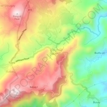
Name: Tiguib topographic map, elevation, terrain.

Location: Tiguib, Malubog, Cebu City, Central Visayas, Philippines (10.35897 123.84842 10.39897 123.88842)

Average elevation: 435 m

Minimum elevation: 139 m

Maximum elevation: 719 m

Other topographic maps

Click on a map to view its topography, its elevation and its terrain.

TIEZA Pond

Philippines > Cebu City > Malubog

Average elevation: 471 m

Gear up for your next adventure:

🧴Sunscreen SPF - Broad-spectrum sunscreen for outdoor activities
🧰Multitool Knife - Compact and versatile tool for outdoor use
🏃Hydration Running Vest - Carry water and maps close to your body for speed
🧥Softshell Jacket - Windproof and breathable jacket for hiking
🚲MTB Frame Bag - Carry tools and maps directly on your bicycle frame

As an Amazon Associate, this site earns from qualifying purchases at no extra cost to you.