
Yaren District topographic map
Interactive map
Click on the map to display elevation.
About this map
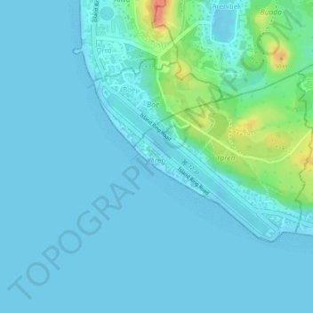
Name: Yaren District topographic map, elevation, terrain.
Location: Yaren District, Yaren, Nauru (-0.55413 166.91436 -0.53952 166.92982)
Average elevation: 9 m
Minimum elevation: -1 m
Maximum elevation: 61 m
Yaren is located in the south of the island. Its area is 1.5 km2 (0.58 sq mi), and its elevation was 25 metres (82 feet) as of 2007. To the north of Yaren is Buada, to the east is Meneng and to the west is Boe.