
Make a donation
Gear up for your next adventure:
As an Amazon Associate, this site earns from qualifying purchases at no extra cost to you.
La Cresse topographic map
Click on the map to display elevation.
Make a donation
Gear up for your next adventure:
As an Amazon Associate, this site earns from qualifying purchases at no extra cost to you.
La Cresse
L'altitude minimale, 372 mètres, se trouve localisée à l'extrême ouest, là où le Tarn quitte la commune et sert de limite entre celles de Compeyre et de Paulhe. L'altitude maximale avec 868 mètres est située dans le sud, à 150 mètres du territoire communal de Millau, près du lieu-dit les Avellongs.
Make a donation
Gear up for your next adventure:
As an Amazon Associate, this site earns from qualifying purchases at no extra cost to you.
About this map
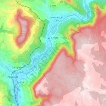
Name: La Cresse topographic map, elevation, terrain.
Average elevation: 630 m
Minimum elevation: 361 m
Maximum elevation: 867 m
Make a donation
Gear up for your next adventure:
As an Amazon Associate, this site earns from qualifying purchases at no extra cost to you.