
Make a donation
Gear up for your next adventure:
As an Amazon Associate, this site earns from qualifying purchases at no extra cost to you.
Verrières topographic map
Click on the map to display elevation.
Make a donation
Gear up for your next adventure:
As an Amazon Associate, this site earns from qualifying purchases at no extra cost to you.
Verrières
Le relief de la commune est celui d'un bas plateau assez vallonné d'une altitude moyenne de 70 m, bordé au sud-ouest par la vallée du Né. Le point culminant de la commune est à une altitude de 98 m, situé en limite nord-est (mont Bouchet). Le point le plus bas est à 21 m, situé le long du Né en limite ouest. Le bourg est à environ 60 m d'altitude.
Make a donation
Gear up for your next adventure:
As an Amazon Associate, this site earns from qualifying purchases at no extra cost to you.
About this map
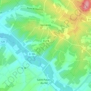
Name: Verrières topographic map, elevation, terrain.
Average elevation: 53 m
Minimum elevation: 20 m
Maximum elevation: 135 m
Make a donation
Gear up for your next adventure:
As an Amazon Associate, this site earns from qualifying purchases at no extra cost to you.