
Peux topographic map
Interactive map
Click on the map to display elevation.
About this map
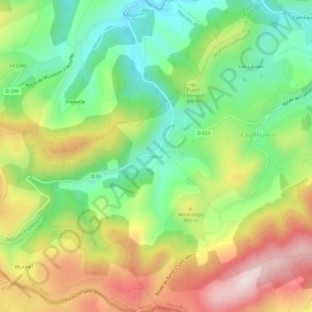
Name: Peux topographic map, elevation, terrain.
Average elevation: 817 m
Minimum elevation: 615 m
Maximum elevation: 1,091 m
Other topographic maps
Click on a map to view its topography, its elevation and its terrain.
Couffouleux
France > Occitanie > Aveyron > Peux-et-Couffouleux
Couffouleux, Peux-et-Couffouleux, Millau, Aveyron, Occitanie, France métropolitaine, 12360, France
Average elevation: 816 m
Fabrègues
France > Occitanie > Aveyron > Peux-et-Couffouleux
Fabrègues, Peux-et-Couffouleux, Millau, Aveyron, Occitanie, France métropolitaine, 12360, France
Average elevation: 706 m