Geolocate

Filderstadt topographic map

Click on the map to display elevation.

About this map

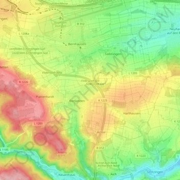
Name: Filderstadt topographic map, elevation, terrain.

Location: Filderstadt, Landkreis Esslingen, Baden-Württemberg, 70794, Germany (48.62376 9.15973 48.69456 9.27031)

Average elevation: 388 m

Minimum elevation: 302 m

Maximum elevation: 492 m

Other topographic maps

Click on a map to view its topography, its elevation and its terrain.

Gear up for your next adventure:

🧴Sunscreen SPF - Broad-spectrum sunscreen for outdoor activities
🧦Hiking Liner Socks - Thin base layer to prevent friction and blisters
🥾Hiking Shorts - Breathable shorts suitable for summer hikes
🍽️Titanium Camping Spork - Ultralight and indestructible eating utensil
🥾Waterproof Hiking Shoes - Durable shoes for wet and rugged trails

As an Amazon Associate, this site earns from qualifying purchases at no extra cost to you.