Geolocate

Gabut topographic map

Click on the map to display elevation.

About this map

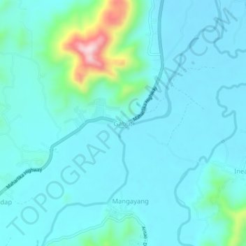
Name: Gabut topographic map, elevation, terrain.

Location: Gabut, Nueva Vizcaya, Cagayan Valley, 3704, Philippines (16.30461 121.05044 16.34461 121.09044)

Average elevation: 384 m

Minimum elevation: 337 m

Maximum elevation: 671 m

Other topographic maps

Click on a map to view its topography, its elevation and its terrain.

Kayapa

Philippines > Nueva Vizcaya

Average elevation: 1,258 m

Kasibu River

Philippines > Nueva Vizcaya > Kasibu

Average elevation: 866 m

Gear up for your next adventure:

💡Compact LED Flashlight - Powerful and portable flashlight for outdoor use
🐕Hiking Dog Pack - Let your canine companion carry their own water and food
🦯Trekking Poles - Reduced impact on joints for steep topographic climbs
🧥Thermal Layer - Insulating layer for cold outdoor conditions
🎒Hiking Backpack - Lightweight and ergonomic backpacks for day hikes or multi-day treks

As an Amazon Associate, this site earns from qualifying purchases at no extra cost to you.