Geolocate

Cochabamba topographic map

Click on the map to display elevation.

About this map

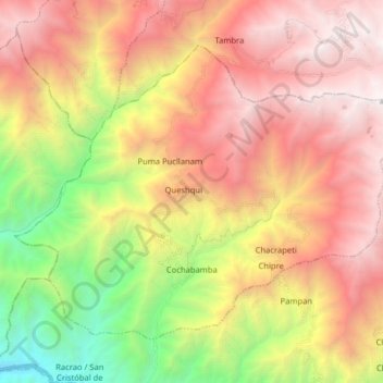
Name: Cochabamba topographic map, elevation, terrain.

Location: Cochabamba, Province of Huaraz, Ancash, Peru (-9.52347 -77.93353 -9.40273 -77.77390)

Average elevation: 2,965 m

Minimum elevation: 860 m

Maximum elevation: 4,850 m

Other topographic maps

Click on a map to view its topography, its elevation and its terrain.

Utupampa

Peru > Ancash

Average elevation: 3,198 m

Huaripampa Alto

Peru > Ancash > San Marcos

Average elevation: 3,392 m

Gear up for your next adventure:

🎒Hiking Backpack - Lightweight and ergonomic backpacks for day hikes or multi-day treks
🧴Insect Repellent - Protect yourself from bugs during outdoor adventures
🛶Waterproof Dry Bags - Keep electronics and clothes dry during river crossings
🧤Thermal Hiking Gloves - Grip-enhanced gloves for cold-weather altitude trekking
🧢Sun Hat - Wide-brim hat for sun protection

As an Amazon Associate, this site earns from qualifying purchases at no extra cost to you.