
Pocono Summit topographic map
Click on the map to display elevation.
About this map
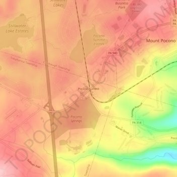
Name: Pocono Summit topographic map, elevation, terrain.
Average elevation: 550 m
Minimum elevation: 445 m
Maximum elevation: 592 m
Other topographic maps
Click on a map to view its topography, its elevation and its terrain.
Pocono Pines
United States > Pennsylvania > Monroe County > Tobyhanna Township > Pocono Pines
Average elevation: 556 m
Emerald Lakes
United States > Pennsylvania > Monroe County > Tobyhanna Township > Emerald Lakes
Average elevation: 578 m
Pocono Lake
United States > Pennsylvania > Monroe County > Tobyhanna Township > Pocono Pines
Average elevation: 537 m
Pocono Pines
United States > Pennsylvania > Monroe County > Tobyhanna Township
Average elevation: 556 m