
Mathews County topographic map
Interactive map
Click on the map to display elevation.
About this map
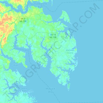
Name: Mathews County topographic map, elevation, terrain.
Location: Mathews County, Virginie, États-Unis (37.27836 -76.45190 37.54222 -76.13630)
Average elevation: 3 m
Minimum elevation: -5 m
Maximum elevation: 32 m
Other topographic maps
Click on a map to view its topography, its elevation and its terrain.
Simeon
États-Unis > Virginie > Rose Hill
Simeon, Rose Hill, Albemarle County, Virginie, 22909, États-Unis
Average elevation: 161 m