
Surkh-Rod topographic map
Interactive map
Click on the map to display elevation.
About this map
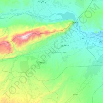
Name: Surkh-Rod topographic map, elevation, terrain.
Location: Surkh-Rod, Nangarhar, Afghanistan (34.31426 70.10104 34.48512 70.46661)
Average elevation: 879 m
Minimum elevation: 556 m
Maximum elevation: 2,102 m
Other topographic maps
Click on a map to view its topography, its elevation and its terrain.
Dschalalabad
Afghanistan > Nangarhar > Dschalalabad
Dschalalabad, Nangarhar, 004847, Afghanistan
Average elevation: 706 m