
Dessie topographic map
Interactive map
Click on the map to display elevation.
About this map
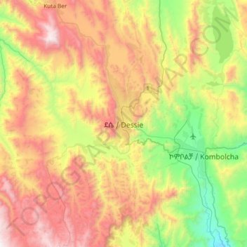
Name: Dessie topographic map, elevation, terrain.
Location: Dessie, South Wollo, Amhara Region, Ethiopia (10.96260 39.47498 11.28260 39.79498)
Average elevation: 2,450 m
Minimum elevation: 1,582 m
Maximum elevation: 3,506 m
Dessie (Amharic: ደሴ, romanized: Däse; also spelled Dese or Dessye) is a city and a zone in north-central Ethiopia. Located in the Amhara Region, it sits at a latitude and longitude of 11°8′N 39°38′E / 11.133°N 39.633°E / 11.133; 39.633, with an elevation between 2,470 and 2,550 metres above sea level. Dessie is 400 km to the north of the capital Addis Ababa. It has a population of more than 200,000 people in over 30 districts.