Geolocate

Pescara topographic map

Click on the map to display elevation.

About this map

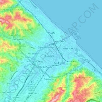
Name: Pescara topographic map, elevation, terrain.

Location: Pescara, Italy (42.41646 14.15277 42.49456 14.25383)

Average elevation: 34 m

Minimum elevation: -3 m

Maximum elevation: 189 m

Other topographic maps

Click on a map to view its topography, its elevation and its terrain.

San Martino Bassa

Italy > Pescara > Città Sant'Angelo

Average elevation: 33 m

Rigopiano

Italy > Pescara > Farindola

Average elevation: 1,182 m

Barberi

Italy > Pescara > Collecorvino

Average elevation: 126 m

Gear up for your next adventure:

Lightweight Camping Tent - Portable shelter optimized for Canadian backcountry camping
Bushcraft Tarp - Versatile emergency shelter or gear protection
🛶Waterproof Dry Bags - Keep electronics and clothes dry during river crossings
🎒Hiking Backpack - Lightweight and ergonomic backpacks for day hikes or multi-day treks
🧢Outdoor Cap - Protective cap for sun and rain during hikes

As an Amazon Associate, this site earns from qualifying purchases at no extra cost to you.