
Isla Rivero topographic map
Interactive map
Click on the map to display elevation.
About this map
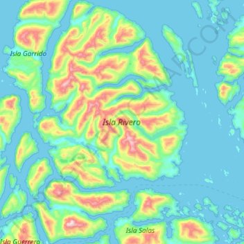
Name: Isla Rivero topographic map, elevation, terrain.
Average elevation: 159 m
Minimum elevation: -1 m
Maximum elevation: 970 m
Other topographic maps
Click on a map to view its topography, its elevation and its terrain.
Isla Huemules
Chile > Región Aysén del General Carlos Ibáñez del Campo > Aysén
Isla Huemules, Aysén, Provincia de Aysén, Región Aysén del General Carlos Ibáñez del Campo, Chile
Average elevation: 134 m
Isla Isquiliac
Chile > Región Aysén del General Carlos Ibáñez del Campo > Aysén
Isla Isquiliac, Aysén, Provincia de Aysén, Región Aysén del General Carlos Ibáñez del Campo, Chile
Average elevation: 167 m
Isla Clemente
Chile > Región Aysén del General Carlos Ibáñez del Campo > Aysén
Isla Clemente, Aysén, Provincia de Aysén, Región Aysén del General Carlos Ibáñez del Campo, Chile
Average elevation: 144 m