Geolocate

Deusto topographic map

Click on the map to display elevation.

About this map

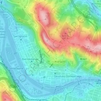
Name: Deusto topographic map, elevation, terrain.

Location: Deusto, Bilbao, Gran Bilbao, Vizcaya, País Vasco, España (43.26529 -2.97135 43.29032 -2.93335)

Average elevation: 68 m

Minimum elevation: -4 m

Maximum elevation: 216 m

Other topographic maps

Click on a map to view its topography, its elevation and its terrain.

Ría de Bilbao

España > País Vasco > Bilbao

Average elevation: 95 m

Pagasarri

España > País Vasco > Bilbao

Average elevation: 434 m

Artxanda

España > País Vasco > Bilbao

Average elevation: 114 m

Gear up for your next adventure:

🧣Evaporative Cooling Towel - Beat the heat during intense summer climbs
🧦Thermal Socks - Warm socks for winter hiking or camping
🥾Hiking Boots - Sturdy boots providing ankle support and traction on rugged trails
🧥Thermal Layer - Insulating layer for cold outdoor conditions
🔭Outdoor Binoculars - Lightweight binoculars for birdwatching and hiking

As an Amazon Associate, this site earns from qualifying purchases at no extra cost to you.