
Make a donation
Gear up for your next adventure:
As an Amazon Associate, this site earns from qualifying purchases at no extra cost to you.
La Butte topographic map
Click on the map to display elevation.
Make a donation
Gear up for your next adventure:
As an Amazon Associate, this site earns from qualifying purchases at no extra cost to you.
About this map
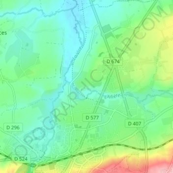
Name: La Butte topographic map, elevation, terrain.
Average elevation: 123 m
Minimum elevation: 84 m
Maximum elevation: 227 m
Make a donation
Gear up for your next adventure:
As an Amazon Associate, this site earns from qualifying purchases at no extra cost to you.
Other topographic maps
Click on a map to view its topography, its elevation and its terrain.
Make a donation
Gear up for your next adventure:
As an Amazon Associate, this site earns from qualifying purchases at no extra cost to you.
Saint-Germain-de-Tallevende-la-Lande-Vaumont
France > Normandie > Calvados > Vire Normandie
Le point culminant (351 m) se situe à l'ouest, près du lieu-dit la Valaiserie et des limites avec Gathemo et Champ-du-Boult. Le sud-ouest et l'ouest sont d'ailleurs jalonnés de collines dépassant toutes 275 mètres d'altitude. Le point le plus bas (125 m) correspond à la sortie de la Virène de la…
Average elevation: 232 m
Sainte-Honorine
France > Normandie > Calvados > Vire Normandie > Sainte-Honorine
Average elevation: 164 m
Vire
France > Normandie > Calvados > Vire Normandie
De 1972 (date de la vision de Saint-Martin-de-Tallevende) à 2015 (date de la fusion au sein de Vire Normandie), Vire avait une superficie de 22,50 km2 ; son altitude variait de 85 à 225 mètres.
Average elevation: 155 m
Make a donation
Gear up for your next adventure:
As an Amazon Associate, this site earns from qualifying purchases at no extra cost to you.