
Derry topographic map
Click on the map to display elevation.
About this map
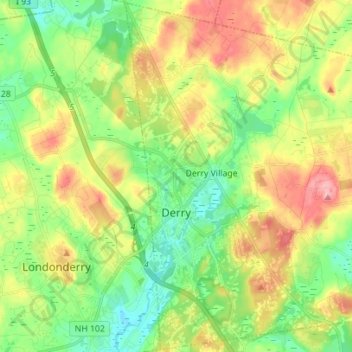
Name: Derry topographic map, elevation, terrain.
Average elevation: 111 m
Minimum elevation: 63 m
Maximum elevation: 181 m
Other topographic maps
Click on a map to view its topography, its elevation and its terrain.
South Beacon Shoal
United States > New Hampshire > Rockingham County > Portsmouth
Average elevation: 4 m
Hampton River
United States > New Hampshire > Rockingham County > Hampton Falls
Average elevation: 1 m
Salem Depot
United States > New Hampshire > Rockingham County > Salem > Salem Depot
Average elevation: 50 m
Rye Beach Village District
United States > New Hampshire > Rockingham County > Rye Beach Village District
Average elevation: 7 m