Geolocate

Paola topographic map

Click on the map to display elevation.

About this map

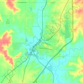
Name: Paola topographic map, elevation, terrain.

Location: Paola, Miami County, Kansas, United States (38.53475 -94.89359 38.62406 -94.83464)

Average elevation: 280 m

Minimum elevation: 255 m

Maximum elevation: 326 m

Other topographic maps

Click on a map to view its topography, its elevation and its terrain.

Beagle

United States > Kansas > Miami County

Average elevation: 291 m

Somerset

United States > Kansas > Miami County

Average elevation: 289 m

Spring Hill

United States > Kansas > Miami County > Spring Hill

Average elevation: 320 m

Gear up for your next adventure:

🧥Insulated Jacket - Keep warm in cold outdoor conditions
🧼Biodegradable Camp Soap - Environmentally friendly cleaning for gear and body
🧭GPS Outdoor Watch - Smart watch for navigation and fitness tracking in nature
🛌Down Sleeping Bag - Superior warmth-to-weight ratio for cold nights
🧥Ultralight Puffy Jacket - Maximum warmth that packs down to the size of an orange

As an Amazon Associate, this site earns from qualifying purchases at no extra cost to you.